
Sète - The Venice of Languedoc
French Home Page |
| Les Fêtes |
| All about Paris |
| U3A French |
| Icons of France |
| Useful Stuff |
|
Sète has roots long back in the past to 1000 BCE. At that time, it was located on an island in a lagoon. In Roman times, it was a haven for ships. The island was called Saint Clair, fishing was the main industry and the town became famous for its pickled fish.
During the Middle Ages, the lagoon silted up, so Sète became a port on the marshy mainland. For a while it was the home of those hunting down privateers for the reward money. Up to the 1700s the town was just a fishing village but it was the creation of the Canal du Midi and King Louis XIV’s support for the project which resulted in the exponential growth of the area.
The Canal was planned to enter the sea at Sète so the port and town were planned specifically for expansion. The construction works for the canal and the city took nearly 15 years, with bridges, aqueducts, and basins being built. The town’s defences were strengthened.
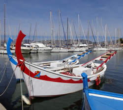
Today the port thrives, being the second fishing port for France on the Mediterranean and an important commercial and trading port.
|


| Did you know? | ||
|
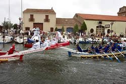
Sète is the largest fishing port on the Mediterranean coast and is known by the locals as the “Venice of Languedoc”. This is because Sète is really like an island set in a lagoon and linked by canals to the sea and the mainland. Jousting in Sète Jousting tournaments have been held during the summer months since 1666. But they are from boats rather than horses. There are two teams, the red and the blue, with eight to ten rowers on each boat.
The red and blue refers to the boat colours, since the jousters themselves have to wear a white uniform. The jouster balances on a platform that extends about 3 metres from the boat over the water. The aim is to use a long spear to tip your opponents into the water. On the lower part of the platform the other jousters wait their turn.
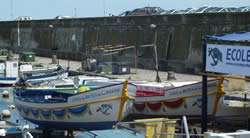
These are jousting boats in St Mandrier, near Toulon. The sport is very popular throughout France. Different regions have slightly different rules. |
||

Page last updated
December 31, 2014 2:25 PM
Penrose![]() Media
Media